The Lidar (Light Detection and Ranging) technique is an advanced form of remote sensing technology that utilizes lasers to illuminate objects and measure the light reflected back from them when they are illuminated. Lidar systems allow for the measurement of elevations, distances, surface roughness, and vegetation heights. Map-making, surveying, navigation, and the guidance of autonomous vehicles are some of the applications it can be used for.
Using LiDAR, detailed information regarding an area, such as topography, vegetation, and buildings, can be captured. The use of LiDAR for mapping and modeling can provide a detailed and accurate display of an area by creating a 3D representation of the area —in the form of 3D LiDAR point clouds. A variety of uses can be derived from this, such as planning and designing projects, monitoring the environment, and identifying hazards.
Primary Components of a LiDAR System
There are four main components of a LiDAR system, including a scanning system, a laser source, a data acquisition system, and a data processing system. Typically, a LiDAR system consists of these four components. As a result, they provide the foundation for an extremely powerful remote sensing technology that can be used in a wide range of applications, such as navigation, mapping, and obstacle detection.
As part of a LiDAR system, a global navigation satellite system (GNSS) is also used to provide position information, an inertial navigation system (INS) to measure the position and orientation of the system, and an inertial measurement unit (IMU) to determine the system’s attitude. Modern LiDAR systems have the ability to capture intensity images of the mapped area as well as range data.
How a LiDAR System Functions
A thorough understanding of the components that comprise a LiDAR system is required in order to use it effectively. LiDAR systems are highly advanced technologies and require a comprehensive understanding of their components. Having a clear understanding of the individual elements of a LiDAR system allows users to determine how the system functions correctly and determine how to obtain the most accurate and detailed information.
- LiDAR sensors measure the time taken for pulses to travel providing 3D LiDAR point clouds as a result;
- LiDAR sensors are controlled by scanners. During the calibration process, the sensor is rotated to ensure that all data points are captured. There are motorized and manual versions available, depending on the application;
- Computers are integrated into LiDAR systems for the purpose of converting raw data collected from LiDAR sensors into usable formats, such as 3D point clouds;
- A system is not complete without its software. An analysis of the data generated by the LiDAR system is carried out by this unit in order to create a 3D model of the surrounding area.
Several factors contribute to the computation of the coordinates of each reflected laser pulse, including the distance or range, the scan angle, the location of the sensor, and the orientation of the sensor. Up to several hundred meters are typically covered by a Lidar system. Analyzing, creating, and converting the 3D map is the responsibility of the processing electronics, based on which the navigation system determines the direction and speed of the vehicle (in autonomous vehicles).
Data Annotation for LiDAR Training
A lidar system requires a significant amount of training to achieve highly accurate results, yet takes a great deal of effort and time. A lidar system that can identify objects and their locations accurately can be created by using large datasets of accurate 3D data. Using data labeling techniques and 3D LiDAR annotations facilitates the development of training data for these systems.
The first step in training the lidar system is to collect data from the environment where it will be used. In order for a LiDAR system to function and display accurate representations of the real environment, this data must be of high quality. Performing pre-processing and cleaning of the collected data will ensure that it is error-free and will not affect the performance of the LiDAR system.
Deploying Data in LiDAR Systems
It is important to create a training dataset of the environment using 3D LiDAR point cloud annotation — it provides a reference point for the system’s algorithms. After the training data is ready, it must be deployed in the LiDAR system using algorithms and neural networks. It will allow the system to identify objects and their locations, discriminate between different types of objects, and accurately predict their positions in the environment.
Lastly, it is crucial to test the system to make sure it is functioning correctly. A simulation in the environment can be run and the results compared to the expected system behavior. It is important to perform this testing process before the system is deployed in the real world in order to identify any potential issues.
Applications Utilizing LiDAR
Land maps, building plans, and other 3D objects are often generated using a LiDAR system. Also, the instrument measures the speed of the wind, the quality of the air, and the amount of cloud cover. In addition to detecting trees and animals, lidar is capable of detecting objects which are difficult to detect with other sensors. Among its other industrial applications are:
- Mapping and Surveying
Objects can be accurately and quickly measured on the Earth’s surface using LiDAR. 3D models of buildings and landscapes can be created using this information for mapping and surveying applications. Digital elevation models and vegetation types can also be created with it. Roads and bridges can also be detected using lidar technology.
- Geological Mapping
Landforms and changes in topography can be accurately measured using LiDAR data, which allows geologists to create high-resolution 3D maps of terrain. Based on this data, geological formations such as valleys, hills, and other features can be mapped. Also, detailed maps can be created by using the data. Geologists find LiDAR useful as it can provide more accurate and detailed maps of the Earth’s surface.
- Monitoring Environmental Changes
Environmental changes can be monitored using Lidar. This instrument is used to demonstrate changes in land cover and vegetation by measuring the reflectance of surfaces (for example, vegetation, terrain, and water). As well as being able to detect changes in topography, such as erosion and landslides, it can also detect differences in surface temperatures in water bodies.
- Object Detection
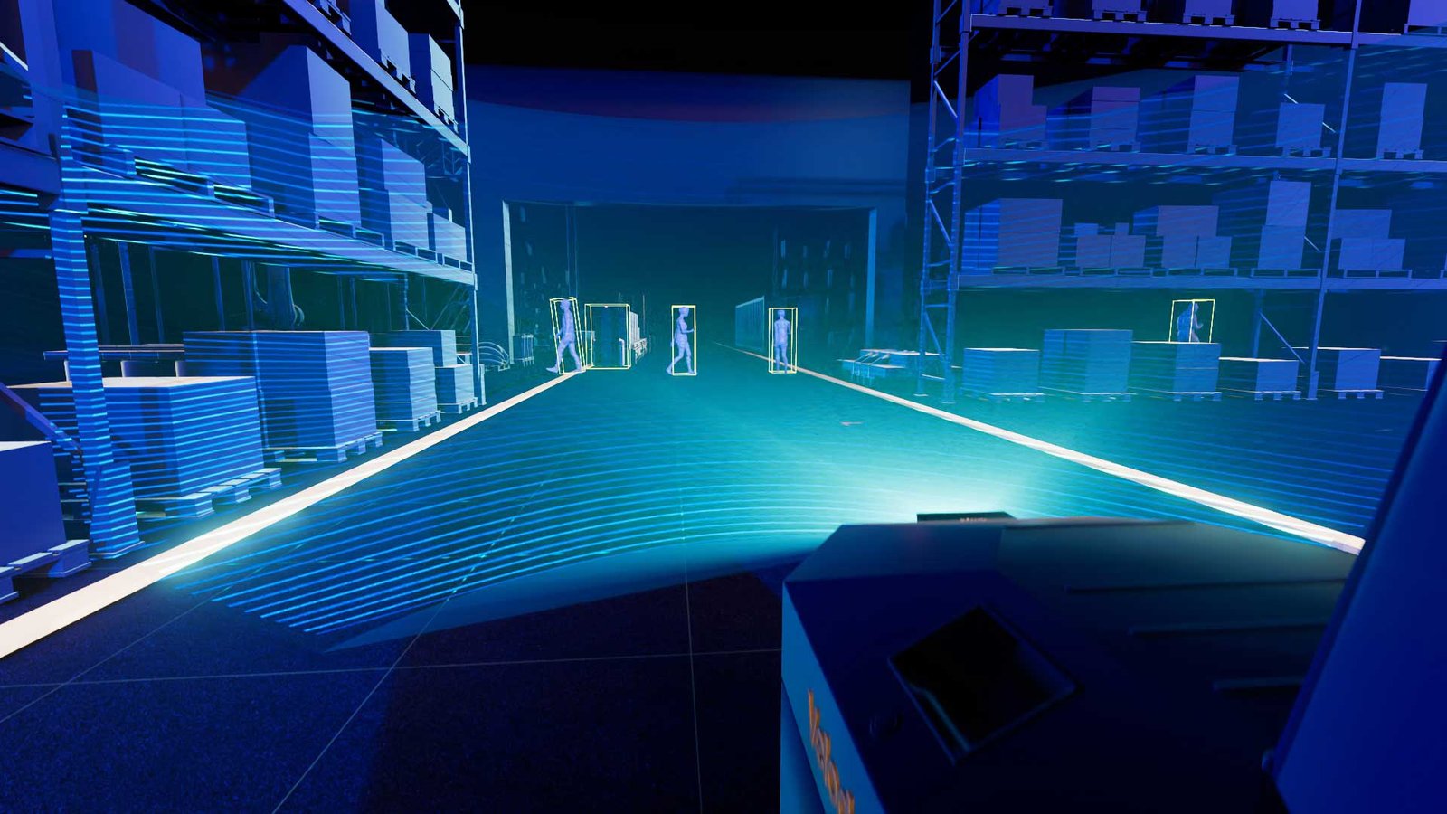
A lidar-based object detection system detects objects in a scene. By using lasers to measure distances between objects, Lidar detects the shape of objects using remote sensing. The sensor provides high resolution and accuracy when detecting objects from different angles. Autonomous cars and robotics use Lidar because it can detect objects in their environment quickly and accurately.
- Autonomous Vehicle Navigation
An autonomous vehicle can utilize LiDAR to acquire information about the environment around it. An object in the environment may be detected using the lidar sensor, including buildings, trees, people, and other vehicles. Using this data, a map of the area is created, from which a route can be planned for the vehicle. In addition to navigating the vehicle autonomously around obstacles, this system is also capable of helping the vehicle reach its destination in a safe manner.
Final Thought
Lidar is an important tool for many different applications, and its use is growing rapidly. With its ability to measure distances and create detailed 3D maps, Lidar is changing the way we view and interact with the world around us. However, the accuracy of the LiDAR system highly depends on the data it is trained on. A 3D LiDAR annotation company can be a valuable asset when it comes to the development of a functional LiDAR system that works well in real-time scenarios without failure.